 |
|
| Zoom on Picture | Index | Index Département | Album-Photo |
|---|
| DEP | FROM / ROUTING | DEP | TO / SIGHTSEEINGS | KM | MAP / OPTIONS | |
|---|---|---|---|---|---|---|
| 35 | Redon | 44 | St Nicolas de Redon | 1 | 1 | IGN 24 |
| Left in D775 after the bridge, immediately left along the river-bank | Lorient - Vannes - Redon - Nantes * Redon - St Malo * Redon - St Just - Redon * Le Gâvre - Redon - Le Gâvre * | |||||
| 44 | St Nicolas-de-Redon | 44 | La Provotaie | 3 | 4 | IGN 24 |
| Left at la Clardaie, cross the Vilaine, right in the Towing-Path | Cross, Stone out of the Shoe of Gargantua (?), Ruins of the Castle, old Village | Lorient - Vannes - Redon - Nantes * Redon - St Malo * Redon - St Just - Redon * Le Gâvre - Redon - Le Gâvre * | ||||
| 44 | La Provotaie | 35 | Brain-sur-Vilaine | 15 | 19 | IGN 24 |
| Towing-Path | Valley of the Vilaine | Redon - St Just - Redon * | ||||
| 35 | Brain-sur-Vilaine | 35 | La Louzais | 2 | 21 | IGN 24 |
| Up on the D55, right to the Alignment, follow the small Road, left in the D59, right in the D55, after 5 Km right through la Chapelle de Gavrain, right in the D177 only at la Goulais, left in the D54 | Valley of the Vilaine, Chapel St Mélaine, Roman Road, Church, Chapel St Vener with Roman Fresco "Venus out of Water" | Redon - St Malo * Bain-de-Bretagne - Le Gâvre * Redon - St Just - Redon * | ||||
| 35 | La Louzais | 35 | Langon | 2 | 23 | IGN 24 |
| D56, at the bridge in D59 upon the Vilaine | Chapel St Vener, alignment, church | Redon - St Malo * Bain-de-Bretagne - Le Gâvre * | ||||
| 35 | Langon | 35 | La Louzais | 2 | 25 | IGN 24 |
| Back to the Towing-Path | ||||||
| 35 | La Louzais | 35 | Port-de-Roche | 6 | 31 | IGN 24 |
| Towing-Path | Valley of the Vilaine | Le Gâvre - Guichen * | ||||
| 35 | Port-de-Roche | 35 | Les Boeuvres | 7 | 38 | IGN 24 |
| Towing Path | Valley of the Vilaine, Gorge of La Corbinière | Le Gâvre - Guichen * | ||||
| 35 | Les Boeuvres | 35 | Port de Guipry | 7 | 45 | IGN 24 |
| Towing Path | Valley of the Vilaine | Le Gâvre - Guichen * | ||||
| 35 | Port de Guipry | 35 | St Malo-de-Phily | 8 | 53 | IGN 24 |
| Towing Path | Valley of the Vilaine | Bain-de-Bretagne - Pont-Réan - Bain-de-Bretagne * Le Gâvre - Guichen * | ||||
| 35 | St Malo-de-Phily | 35 | Halte de Laillé | 16 | 69 | IGN 16 |
| D577 (Trafic!), right after La Provotaie, follow the Signs "Moulin du Boël", Towing Path | Valley of the Vilaine | Fougères - Vitré - Guichen * Le Gâvre - Guichen * Guichen - Monfort-sur-Meu - Guichen * Paimboeuf - Le Rozay - Paimboeuf * | ||||
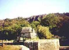
| 35 | Halte de Laillé | 35 | Le Boël | 2 | 71 | IGN 16 |
| D719, along the Bank of the Loire. Left to the City | Mill | |||||
| 35 | Le Boël | 35 | Pont-Réan | 2 | 73 | IGN 16 |
| To D99, right | Alte Brücke | Guichen - Monfort-sur-Meu - Guichen * | ||||
Codewriter: Visual Basic Application - Programmed by : Marzina Bernez
Webdesign, Contents & Copyright : Marzina Bernez - Version : 13.02.2010
URL http://marzina.free.fr/dept00/k/k000162.html