| | => La Louzais
(35) |
KM: 7 | CARTE: IGN 24 |
| DE | An der Vilaine | Römer
Brücke |
| EN | Along the Vilaine | Roman
bridge |
| FR | Le long de la Vilaine |
Pont romain |
| IT | Lungo la Vilaine | Ponte
romano |
| |
||||
|
Bain-de-Bretagne - Le Gâvre |
| | Strecke |
Itinerary |
Itinéraire |
Itinerario |
| |
| |
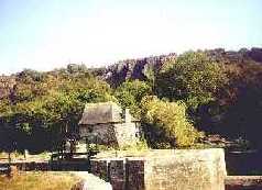
| | => Les Boeuvres
(35) |
KM: 7 | CARTE: IGN 24 |
| DE | Treidelpfad | Tal der
Vilaine, Schlucht La Corbinière |
| EN | Towing Path | Valley of
the Vilaine, Gorge of La Corbinière |
| FR | Chemin de halage | Vallée
de la Vilaine, gorges de la Corbinière |
| IT | Strada alzaia | Valle
della Vilaine, stretta di La Corbinière |
| |
||||
| La Vilaine:
Redon - Pont-Réan |
| | Strecke |
Itinerary |
Itinéraire |
Itinerario |
| |
| |
||||
| Le Gâvre -
Guichen |
| | Strecke |
Itinerary |
Itinéraire |
Itinerario |
| |
| |