 |
|
| Zoom Foto Titolo | Benvenuti | Index | Index Département | Album-Photo |
|---|
| DEP | DA / PERCORSO | DEP | A / DA VEDERE | KM | MAPPA / OPZIONI | |
|---|---|---|---|---|---|---|
| 35 | Redon | 44 | St Nicolas de Redon | 1 | 1 | IGN 24 |
| Dopo il ponte a sinistra nella D775, immediatamente a sinistra lungo l’argine | Lorient - Vannes - Redon - Nantes * Redon - St Malo * Redon - St Just - Redon * Le Gâvre - Redon - Le Gâvre * | |||||
| 44 | St Nicolas-de-Redon | 44 | La Provotaie | 3 | 4 | IGN 24 |
| A sinistra a la Clardaie, attraversare la Vilaine, a destra nella strada alzaia | Croce, sasso della scarpa di Gargantua (?), rovine del castello, vecchio villaggio | Lorient - Vannes - Redon - Nantes * Redon - St Malo * Redon - St Just - Redon * Le Gâvre - Redon - Le Gâvre * | ||||
| 44 | La Provotaie | 35 | Brain-sur-Vilaine | 15 | 19 | IGN 24 |
| Strada alzaia | Valle della Vilaine | Redon - St Just - Redon * | ||||
| 35 | Brain-sur-Vilaine | 35 | La Louzais | 2 | 21 | IGN 24 |
| Salire per la D55, a destra verso l’allineamento, seguire la piccola stra, a sinistra nella D59, a destra nella D55, dopo 5 Km a destra per la Chapelle de Gavrain, a destra nella D177 soltanto a la Goulais, a sinistra nella D54 | Valle della Vilaine, cappella St Mélaine, via romana, chiesa, cappella St Vener con affresco romano "Venere uscendo dall’acqua" | Redon - St Malo * Bain-de-Bretagne - Le Gâvre * Redon - St Just - Redon * | ||||
| 35 | La Louzais | 35 | Langon | 2 | 23 | IGN 24 |
| D56, prendere la D59 al ponte sulla Vilaine | Cappella St Vener, alignement, chiesa | Redon - St Malo * Bain-de-Bretagne - Le Gâvre * | ||||
| 35 | Langon | 35 | La Louzais | 2 | 25 | IGN 24 |
| Ritornare sulla strada alzaia | ||||||
| 35 | La Louzais | 35 | Port-de-Roche | 6 | 31 | IGN 24 |
| Strada alzaia | Valle della Vilaine | Le Gâvre - Guichen * | ||||
| 35 | Port-de-Roche | 35 | Les Boeuvres | 7 | 38 | IGN 24 |
| Strada alzaia | Valle della Vilaine, stretta di La Corbinière | Le Gâvre - Guichen * | ||||
| 35 | Les Boeuvres | 35 | Port de Guipry | 7 | 45 | IGN 24 |
| Strada alzaia | Valle della Vilaine | Le Gâvre - Guichen * | ||||
| 35 | Port de Guipry | 35 | St Malo-de-Phily | 8 | 53 | IGN 24 |
| Strada alzaia | Valle della Vilaine | Bain-de-Bretagne - Pont-Réan - Bain-de-Bretagne * Le Gâvre - Guichen * | ||||
| 35 | St Malo-de-Phily | 35 | Halte de Laillé | 16 | 69 | IGN 16 |
| D577 (circolata!), a destra dopo la Provotaie, seguire i segni "Moulin du Boël", strada alzaia | Valle della Vilaine | Fougères - Vitré - Guichen * Le Gâvre - Guichen * Guichen - Monfort-sur-Meu - Guichen * Paimboeuf - Le Rozay - Paimboeuf * | ||||
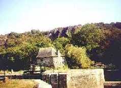
| 35 | Halte de Laillé | 35 | Le Boël | 2 | 71 | IGN 16 |
| D719, poi sull’argine della Loira. A sinistra verso il centro | Mulino | |||||
| 35 | Le Boël | 35 | Pont-Réan | 2 | 73 | IGN 16 |
| Verso D99, a destra | Vieux pont | Guichen - Monfort-sur-Meu - Guichen * | ||||
Codewriter: Visual Basic Application - Programmed by : Marzina Bernez
Webdesign, Contents & Copyright : Marzina Bernez - Version : 13.02.2010
URL http://marzina.free.fr/dept00/k/k000164.html